New Zealand-"Land of the long white cloud"
1.„Treaty of Waitangi“ is the New Zealand’s founding document. About 40 chiefs signed the Treaty of Waitangi on 6 February 1840. By the end of the year, about 500 other Maori, including 13 women, had put their names or moko to the document; all but 39 signed the Maori text. While some had clear expectations about what their agreement would bring, others chose not to sign the Treaty at all.
Lieutenant-Governor William Hobson expected the chiefs to mull over the Maori text of the Treaty for three days. He was surprised to be called to the meeting on 6 February, so he arrived at Waitangi alone and in plain clothes except for his plumed hat. Former British Resident James Busby called up the chiefs, starting with Hone Heke. Each signing was followed by a handshake and greeting from Hobson: 'He iwi tahi tatou' (We are [now] one people). About half of the chiefs had also signed the Declaration of Independence.
Around 6 February, Henry Williams translated a copy of the Maori text back into English. This became the official text of the Treaty in English. It was presumed that the Maori text and translation back into English had the same meaning, but Williams added a note on the copy of the official text that Hobson sent to Governor Gipps, which said 'I certify that the above is as literal a translation of the Treaty of Waitangi as the idiom of the language will allow.'
The Treaty of Waitangi got it’s name from the first place people signed it.
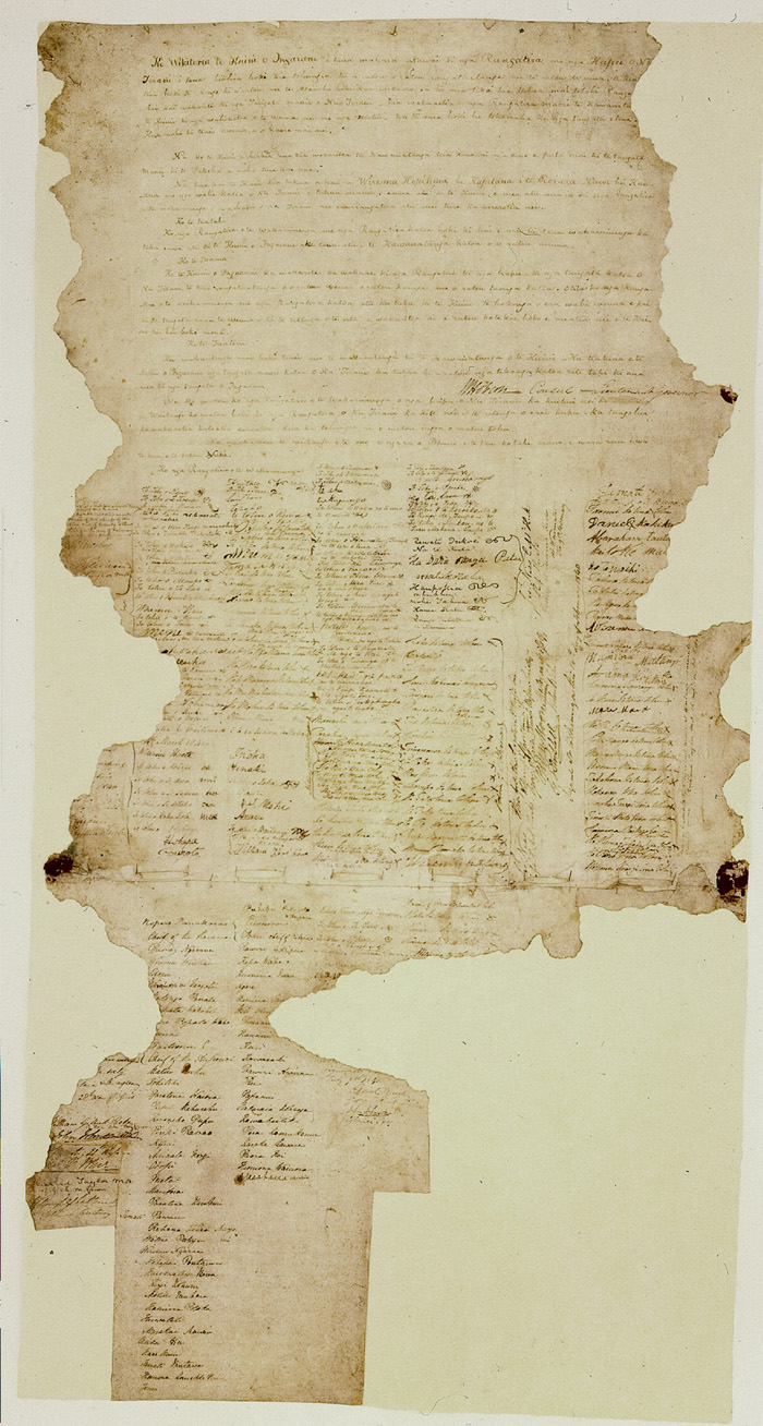
(http://www.treatyofwaitangi.net.nz/Original%20Treaty%20of%20Waitangi.JPG) 30.01.2010
Text from http://www.nzhistory.net.nz
2.The weta is native to New Zealand. It is a rather large insect. While harmless to humans, its bite can be painful. It is a protected species, and, despite its repellent aspect, may not be harmed.

(http://www.bearsinthecity.com.au/wp-content/uploads/2008/09/weta.jpg) 30.01.2010
Text from http://www.nz.com/new-zealand/guide-book/
3.The highly acclaimed "Lord of the Rings" was filmed entirely in New Zealand. American producers were skeptical and the fact that Peter Jackson had never directed a film of that magnitude didn't help matters.
The Lord of the Rings film trilogy consists of three live action fantasy epic films: The Fellowship of the Ring (2001), The Two Towers (2002) and The Return of the King (2003). The trilogy is based on the three-volume book The Lord of the Rings by J. R. R. Tolkien. While they follow the book's general storyline, the films also feature some additions to and deviations from the source material.
Set in the fictional world of Middle-earth, the three films follow the hobbit Frodo Baggins as he and a Fellowship embark on a quest to destroy the One Ring, and thus ensure the destruction of its maker, the Dark Lord Sauron. The Fellowship becomes divided and Frodo continues the quest together with his loyal companion Sam and the treacherous Gollum. Meanwhile, the wizard Gandalf and Aragorn, heir in exile to the throne of Gondor, unite and rally the Free Peoples of Middle-earth, who are ultimately victorious in the War of the Ring.The films were directed by Peter Jackson and distributed by New Line Cinema. Considered to be one of the biggest and most ambitious movie projects ever undertaken, with an overall budget of $285 million, the entire project took eight years, with the filming for all three films done simultaneously and entirely in Jackson's native New Zealand. Each film in the trilogy also had Special Extended Editions, released on DVD a year after the theatrical releases.
The trilogy was a great financial success, with the films being among the highest-grossing films of all time. The films were critically acclaimed, winning 17 out of 30 Academy Awards nominated in total, and received wide praise for the cast and for the innovative practical and digital special effects.

(http://upload.wikimedia.org/wikipedia/en/8/87/Ringstrilogyposter.jpg) 4.02.2010
Text from http://hubpages.com/hub/Fun-Facts-About-New-Zealand
and from http://en.wikipedia.org/wiki/Main_Page
4.The early European settlers divided New Zealand into provinces. These were abolished in 1876 so that government could be centralised, for financial reasons. As a result, New Zealand has no separately represented subnational entities such as provinces, states or territories, apart from local government. However the spirit of the provinces lives on, and there is fierce rivalry exhibited in sporting and cultural events. Since 1876, local government has administered the various regions of New Zealand. In 1989, the government completely reorganised local government, implementing the current two-tier structure of regional councils and territorial authorities constituted under the Local Government Act 2002. In 1991, the Resource Management Act 1991 replaced the Town and Country Planning Act as the main planning legislation for local government.
New Zealand has 12 regional councils for the administration of regional environmental and transport matters and 73 territorial authorities that administer roading, sewerage, building consents, and other local matters. The territorial authorities are 16 city councils, 57 district councils, and the Chatham Islands Council. Four of the territorial councils (one city and three districts) and the Chatham Islands Council also perform the functions of a regional council and are known as unitary authorities. Territorial authority districts are not subdivisions of regional council districts, and a few of them straddle regional council boundaries.
The regions are (asterisks denote unitary authorities): Northland, Auckland, Waikato, Bay of Plenty, Gisborne*, Hawke's Bay, Taranaki, Manawatu-Wanganui, Wellington, Marlborough*, Nelson*, Tasman*, West Coast, Canterbury, Otago, Southland, Chatham Islands*.
New Zealand's head of state is the Queen of New Zealand, currently Elizabeth II. The New Zealand monarchy has been distinct from the British monarchy since the New Zealand Royal Titles Act of 1953, and all Elizabeth II's official business in New Zealand is conducted in the name of the Queen of New Zealand, not the Queen of the United Kingdom. In practice, the functions of the monarchy are conducted by a Governor-General, appointed by the monarch on the advice of the Prime Minister. Under Letters Patent regulating the office of Governor-General, which are granted by the Queen on the advice of the Prime Minister, when there is a vacancy in the office of Governor-General, several of the duties of the said office are exercised by a caretaker, known as the Administrator of the Government. As of 2007, the Governor-General is Anand Satyanand.
There are several languages of New Zealand. English is the dominant and a de facto official language, spoken by most New Zealanders.] The country's two de jure official languages are Māori and New Zealand Sign Language (NZSL). Other languages are also used by ethnic communities.
Text from http://en.wikipedia.org 30.01.2010
5. The New Zealand Flag is the symbol of the realm government and people of New Zealand. Its royal blue background is reminiscent of the blue sea and clear sky surrounding us. The stars of the Southern Cross emphasise this country's location in the South Pacific Ocean. The Union Flag gives recognition to our historical foundations and the fact that New Zealand was once a British colony and dominion.
The New Zealand Flag may be flown on any day of the year. It is particularly appropriate to fly it on days of national commemoration, such as Anzac Day, and on other important occasions.
As New Zealand's national symbol the New Zealand Flag should be treated in a manner worthy of its high status. The Flags, Emblems, and Names Protection Act 1981, administered by the Ministry for Culture and Heritage, defines and protects the Flag. Contained in the Act is the power to prosecute those who misuse it.

(http://mch.govt.nz/nzflag/images/nz-flag.jpg)
3.The highly acclaimed "Lord of the Rings" was filmed entirely in New Zealand. American producers were skeptical and the fact that Peter Jackson had never directed a film of that magnitude didn't help matters.
The Lord of the Rings film trilogy consists of three live action fantasy epic films: The Fellowship of the Ring (2001), The Two Towers (2002) and The Return of the King (2003). The trilogy is based on the three-volume book The Lord of the Rings by J. R. R. Tolkien. While they follow the book's general storyline, the films also feature some additions to and deviations from the source material.
Set in the fictional world of Middle-earth, the three films follow the hobbit Frodo Baggins as he and a Fellowship embark on a quest to destroy the One Ring, and thus ensure the destruction of its maker, the Dark Lord Sauron. The Fellowship becomes divided and Frodo continues the quest together with his loyal companion Sam and the treacherous Gollum. Meanwhile, the wizard Gandalf and Aragorn, heir in exile to the throne of Gondor, unite and rally the Free Peoples of Middle-earth, who are ultimately victorious in the War of the Ring.The films were directed by Peter Jackson and distributed by New Line Cinema. Considered to be one of the biggest and most ambitious movie projects ever undertaken, with an overall budget of $285 million, the entire project took eight years, with the filming for all three films done simultaneously and entirely in Jackson's native New Zealand. Each film in the trilogy also had Special Extended Editions, released on DVD a year after the theatrical releases.
The trilogy was a great financial success, with the films being among the highest-grossing films of all time. The films were critically acclaimed, winning 17 out of 30 Academy Awards nominated in total, and received wide praise for the cast and for the innovative practical and digital special effects.
(http://upload.wikimedia.org/wikipedia/en/8/87/Ringstrilogyposter.jpg) 4.02.2010
Text from http://hubpages.com/hub/Fun-Facts-About-New-Zealand
and from http://en.wikipedia.org/wiki/Main_Page
4.The early European settlers divided New Zealand into provinces. These were abolished in 1876 so that government could be centralised, for financial reasons. As a result, New Zealand has no separately represented subnational entities such as provinces, states or territories, apart from local government. However the spirit of the provinces lives on, and there is fierce rivalry exhibited in sporting and cultural events. Since 1876, local government has administered the various regions of New Zealand. In 1989, the government completely reorganised local government, implementing the current two-tier structure of regional councils and territorial authorities constituted under the Local Government Act 2002. In 1991, the Resource Management Act 1991 replaced the Town and Country Planning Act as the main planning legislation for local government.
New Zealand has 12 regional councils for the administration of regional environmental and transport matters and 73 territorial authorities that administer roading, sewerage, building consents, and other local matters. The territorial authorities are 16 city councils, 57 district councils, and the Chatham Islands Council. Four of the territorial councils (one city and three districts) and the Chatham Islands Council also perform the functions of a regional council and are known as unitary authorities. Territorial authority districts are not subdivisions of regional council districts, and a few of them straddle regional council boundaries.
The regions are (asterisks denote unitary authorities): Northland, Auckland, Waikato, Bay of Plenty, Gisborne*, Hawke's Bay, Taranaki, Manawatu-Wanganui, Wellington, Marlborough*, Nelson*, Tasman*, West Coast, Canterbury, Otago, Southland, Chatham Islands*.
New Zealand's head of state is the Queen of New Zealand, currently Elizabeth II. The New Zealand monarchy has been distinct from the British monarchy since the New Zealand Royal Titles Act of 1953, and all Elizabeth II's official business in New Zealand is conducted in the name of the Queen of New Zealand, not the Queen of the United Kingdom. In practice, the functions of the monarchy are conducted by a Governor-General, appointed by the monarch on the advice of the Prime Minister. Under Letters Patent regulating the office of Governor-General, which are granted by the Queen on the advice of the Prime Minister, when there is a vacancy in the office of Governor-General, several of the duties of the said office are exercised by a caretaker, known as the Administrator of the Government. As of 2007, the Governor-General is Anand Satyanand.
There are several languages of New Zealand. English is the dominant and a de facto official language, spoken by most New Zealanders.] The country's two de jure official languages are Māori and New Zealand Sign Language (NZSL). Other languages are also used by ethnic communities.
Text from http://en.wikipedia.org 30.01.2010
5. The New Zealand Flag is the symbol of the realm government and people of New Zealand. Its royal blue background is reminiscent of the blue sea and clear sky surrounding us. The stars of the Southern Cross emphasise this country's location in the South Pacific Ocean. The Union Flag gives recognition to our historical foundations and the fact that New Zealand was once a British colony and dominion.
The New Zealand Flag may be flown on any day of the year. It is particularly appropriate to fly it on days of national commemoration, such as Anzac Day, and on other important occasions.
As New Zealand's national symbol the New Zealand Flag should be treated in a manner worthy of its high status. The Flags, Emblems, and Names Protection Act 1981, administered by the Ministry for Culture and Heritage, defines and protects the Flag. Contained in the Act is the power to prosecute those who misuse it.
(http://mch.govt.nz/nzflag/images/nz-flag.jpg)
Surprisingly, many people are not aware of the special significance attached to the New Zealand Flag. Within certain guidelines, the New Zealand Flag may be used in a number of ways. Similarly, the correct way to display the New Zealand Flag varies from one situation to another. The aim of this website is to simplify flag flying, which otherwise may seem too complicated and not worth the trouble. It contains a description of the New Zealand Flag and an outline of its history. Certain restrictions placed on the use of the Flag are explained.
Guidance is given on the appropriate choice of a flag and on the care of the Flag. Other flags, often flown alongside the New Zealand Flag or confused with it, are also described briefly.
The New Zealand Flag features, on a royal blue background, a Union Jack in the first quarter and four five-pointed red stars of the Southern Cross on the fly. The stars have white borders.
The notice that appeared in the New Zealand Gazette, 27 June 1902, gave the following technical description of the stars and their positions on the New Zealand Flag.
"The centres of the stars forming the long limb of the cross shall be on a vertical line on the fly, midway between the Union Jack and the outer edge of the fly, and equidistant from its upper and lower edges; and the distance apart of the centres of the stars shall be equal to thirty-six sixtieths the hoist of the ensign.
The centres of the stars forming the short limb of the cross shall be on a line intersecting the vertical limb at an angle of 82 therewith, and rising from near the lower fly corner of the Union Jack towards the upper fly corner of the ensign, its point of intersection with the vertical line being distant from the centre of the uppermost star of the cross twelve-sixtieths of the hoist of the ensign. The distance of the centre of the star nearest the outer edge of the fly from the point of intersection shall be equal to twelve-sixtieths of the hoist of the ensign, and the distance of the centre of the star nearest the Union Jack from the point of intersection shall be equal to fourteen-sixtieths of the hoist of the ensign.
The star nearest the fly edge of the ensign shall measure five-sixtieths, the star at the top of the cross and that nearest to the Union Jack shall each measure six-sixtieths, and the star at the bottom of the cross shall measure seven-sixtieths of the hoist of the ensign across their respective red points, and the width of the white borders to the several stars shall in all cases be equal to one one-hundred-and-twentieth of the hoist of the ensign."
The New Zealand Flag may be made to any size, but in all cases the length should be twice the width.
Text from http://mch.govt.nz/nzflag/index.html 30.01.2010
6. In New Zealand 3.047 million people use internet (2008).
Text from https://www.cia.gov/index.html 30.01.2010
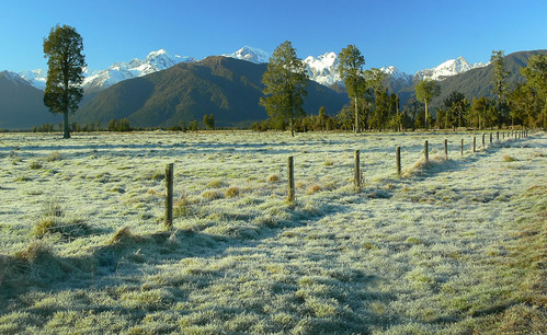
7. In the New Zealand there are 14 national parks containing an incredible variety of unspoiled landscape and vegetation. Administered and maintained by the Department of Conservation Te Papa Atawhai, these parks provide opportunity for a wide variety of activities including hiking, mountain biking, skiing and snowboarding, kayaking and trout fishing. Most national parks have excellent hiking tracks and camping facilities, including nearly 1000 huts throughout the country.
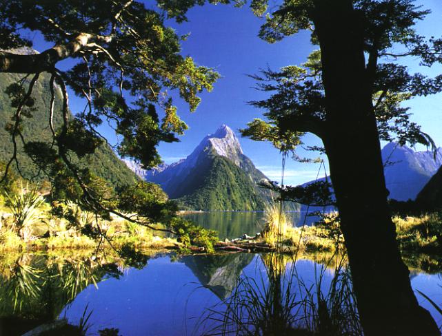
Fiordland NP- The eighth wonder of the world
The seaward edge of Fiordland National Park is a series of fourteen massive knife cuts, carved by the glaciers during successive ice ages.
Towering, snow-capped peaks reflect in the midnight blue fingers of ocean that reach into the park's thickly forested interior, where you can find trees that are more than 800 years old. For sheer drama, few places of earth can compete with this remarkable natural environment.
In 1990 Fiordland was listed as a United Nations World Heritage site and given the name Te Wahipounamu - 'the place of greenstone', after the area's most treasured mineral resource.
A fiord is defined as a u-shaped glacier-carved valley which has been flooded by the sea. The fourteen fiords that fringe the southwest corner of the South Island were 100,000 years in the making, with the final details added during the most recent ice age just 10,000 years ago. The Maori attributed the creation of the fiords to a giant stonemason called Tute Rakiwhanoa, who hued out the steep sided valleys with his adzes.
On all sides of the fiords, spectacular waterfalls tumble incessantly as the region's plentiful rainfall finds its way to the sea.
The remaining two thirds of Fiordland National Park are covered by virgin beech and podocarp forest. A 500 kilometre network of walking tracks allows visitors to explore the primeval world of mountain peaks, alpine lakes and moss-carpeted valleys.
(http://gardenwebs.net/Mitre.Peak.jpg)
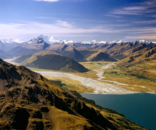
Mount Aspiring NP- Named for Mt Aspiring, one of New Zealand's highest peaks, this park is a dreamland of mountains, glaciers, river valleys and alpine lakes.
In the past, Maori trekked through the region on their way to the pounamu fields of the west coast; Europeans visited to map, name and explore geographical features of the area; settlers attempted to farm and mine some of the valleys - the relics have blended into the stunning scenery.
In straddling the 'great divide' of the Southern Alps, the Mount Aspiring National Park presents a breathtaking range of landscapes.
At its heart is a massive area of wilderness - glaciers, snowfields, mountains, valleys and wildlife habitats that require days of hiking to reach. To the west of the divide, where rainfall is plentiful, the beech forest comes with a sound track of birdsong and waterfalls. Deep in the glacier-gouged valleys of the east, grassy river flats are hemmed by imposing mountains. And above the tree line, subalpine gardens of tussock, lichens and dainty flowering herbs survive against all odds.
Rock forms are an unforgettable feature of the park. From the curiously coloured slopes of the Red Hills to the brittle grey schist of the alps, ice ages and huge tectonic upheavals have created beauty with a hard edge.
Aoraki/Mount Cook NP- The Aoraki/Mount Cook National Park is alpine in the purest sense - with skyscraping peaks, glaciers and permanent snow fields. Aoraki/Mount Cook, New Zealand's tallest mountain, helped Sir Edmund Hillary to develop his climbing skills in preparation for the conquest of Everest.
According to Ngai Tahu legend, Aoraki and his three brothers were the sons of Rakinui, the Sky Father. While on a sea voyage, their canoe overturned on a reef. When the brothers climbed on top of their canoe, the freezing south wind turned them to stone. The canoe became the South Island (Te Waka o Aoraki); Aoraki and his brothers became the peaks of the Southern Alps. Although it encompasses 23 peaks over 3000 metres high, this park is very accessible. State Highway 80 leads to Aoraki/Mount Cook Village which is situated beside scenic Lake Pukaki and provides a comfortable base for alpine activities.
Mountaineers regard the area to be the best climbing region in Australasia, while less skilled adventurers find plenty of satisfaction with the mountain walks that lead to alpine tarns, herb fields and spectacular glacier views. Encounters with cheeky kea (mountain parrots) are part of the fun.
At 27 kilometres in length, the mighty Tasman Glacier is a powerful piece of landscaping equipment. While it slowly carves the valley sides, it provides a landing place for small ski planes and helicopters. Surreal, milky lakes are a feature of the park - suspended, glacier-ground rock sediment makes the water opaque.

(http://www.igpoty.com/competition02/winners/3_PlantPortraits/image1_XL.jpg)
Westland/Tai Poutini NP- There are more than 60 glaciers in the Westland/Tai Poutini National Park. Two of them - the Fox and the Franz Josef - are the only glaciers in the world to flow down to temperate rainforest.
The glaciers stem from snowfields high in the Southern Alps, but Maori legend explains their existence more poetically. It is said that a beautiful girl named Hinehukatere loved the mountains in this park and encouraged her lover, Tawe, to climb them with her. He slipped and fell to his death and Hinehukatere's tears formed the glaciers. The area is known as "Ka Roimata o Hinehukatere" - the tears of the avalanche girl.
From peaks that are over 3000 metres high to lowland rainforest at the edge of the Tasman Sea, this park is an exquisitely beautiful slice of wilderness.
For many travellers, the fast-moving Fox and Franz Josef glaciers are the primary reason to visit. They move up to four metres every day, which in the glacier world is uncommonly rapid (the Tasman Glacier, on the eastern side of the great divide, moves at only 650 millimetres a day). At the foot of each glacier, you can hear the grinding, crushing sounds of ancient ice forcing itself down the time-worn valleys.
Between the glaciers and the sea, the park is a bird watcher's paradise. Rainforest and large areas of wetland shelter rare species such as the Okarito Brown Kiwi, Southern Crested Grebe (kamana) and White Heron (kotuku).
(http://farm1.static.flickr.com/176/461057840_a11afd9629.jpg)
Paparoa NP- The Paparoa National Park was created in 1987, to protect a unique limestone karst environment from mining and forestry. In the interests of science, the boundaries of the park were carefully established to encompass a complete range of landscapes and ecosystems - from the granite and gneiss summits of the Paparoa Range down to the layered rock formations of Punakaiki.
By following the historic Inland Pack Track, formed originally by gold miners, visitors can discover some of the park's most special places. Camping under a natural rock shelter - the Ballroom Overhang - is an unforgettable experience.
Limestone underlies most of the park, and is responsible for the area's impressive landforms. Sculptured mountain ridges, mysterious river canyons, delicate cave decorations and the bizarre, pancake-like coastal formations will keep your camera busy. Maori travellers knew Punakaiki as a place for feasting (Punakaiki means 'a spring of food').
The park is the overlapping point between subtropical and cool climate trees. Nikau palms, northern rata and cabbage trees give the lowland rainforest a lush, Pacific feeling. Further up, silver beech forest merges with sub alpine shrubs. Higher still, daisies and gentians provide colour among the alpine tussocks. Some plants are unique to the area, suggesting that it was a botanic refuge during the ice ages.
Birdlife is prolific in the Paparoa National Park. The endemic Westland Black Petrel breeds only on the Punakaiki coast, and the Great Spotted Kiwi combs the forest by night.
Arthurs Pass- Arthur's Pass is the highest pass over the Southern Alps. Long before surveyor Arthur Dudley Dobson found his way over the pass in 1864, it was known to Maori hunting parties as a route between east and west.
The eastern side of Arthur's Pass National Park is characterised by wide, shingle-filled riverbeds and vast beech forests. The western side of the park, where wet weather is more common than dry, has deeply gorged rivers flowing through dense rainforest. Down the middle of 'the great divide' is an alpine dreamland of snow-covered peaks, glaciers and scree slopes.
The park includes many peaks over 2000 metres - the highest is Mount Murchison at 2,400 metres. All the main valleys of the park are deep and steep sided, with the U-shaped profile typical of glacial action. Above the sub-alpine shrublands, there are enchanting alpine fields with wild flowers.
Most people arrive in Arthur's Pass National Park by road - a spectacular piece of extreme civil engineering involving viaducts, bridges, rock shelters and waterfalls redirected into chutes. When Arthur Dobson first encountered the precipitous Otira Gorge, the pass was almost impassable - he had to leave his horse at the top and lower his dog on a rope.
The village at Arthur's Pass is the starting point for many short walks. The entrance to the historic Otira rail tunnel can be seen here - an epic engineering feat through 8.5 kilometres of rock.

(http://www.laupichler.name/dieter/images/459ArthursPassKea.jpg)
Nelson Lakes NP- A compact area of mountain ranges separated by forested valleys, the Nelson Lakes National Park promises all levels of challenge for keen hikers and mountaineers.
In Maori mythology the lakes were created by the great chief Rakaihaitu digging holes with his ko (digging stick). One hole became Lake Rotoiti (small waters) and the other became Lake Rotoroa (large waters).
Known for its magical honeydew beech forests, which feed a variety of tuneful nectar-eating native birds, the park provides an easy wilderness escape. The nearby village of St Arnaud is a comfortable, well-equipped base for visitors.
The spectacular landscape of Nelson Lakes National Park was sculpted by massive glaciers during the most recent ice ages, and many glacial landforms remain - lakes Rotoiti and Rotoroa are the two most obvious examples.
From January to April, the thick beech forest that cloaks the lower regions of the park shimmers with a coat of honeydew, filling the air with a delicious sweetness. The honeydew - each drop poised on the end of a threadlike tube that protrudes from the trunk of the tree - is created by scale insects, which process the tree sap into pure sugar. For many native birds, lizards and insects, the honeydew is a source of high-energy food.
The Department of Conservation is actively working in the park to create a pest-free refuge that will support greater numbers of kaka, kakariki and bush robins, as well as giant snails and native bats.

The eastern side of Arthur's Pass National Park is characterised by wide, shingle-filled riverbeds and vast beech forests. The western side of the park, where wet weather is more common than dry, has deeply gorged rivers flowing through dense rainforest. Down the middle of 'the great divide' is an alpine dreamland of snow-covered peaks, glaciers and scree slopes.
The park includes many peaks over 2000 metres - the highest is Mount Murchison at 2,400 metres. All the main valleys of the park are deep and steep sided, with the U-shaped profile typical of glacial action. Above the sub-alpine shrublands, there are enchanting alpine fields with wild flowers.
Most people arrive in Arthur's Pass National Park by road - a spectacular piece of extreme civil engineering involving viaducts, bridges, rock shelters and waterfalls redirected into chutes. When Arthur Dobson first encountered the precipitous Otira Gorge, the pass was almost impassable - he had to leave his horse at the top and lower his dog on a rope.
The village at Arthur's Pass is the starting point for many short walks. The entrance to the historic Otira rail tunnel can be seen here - an epic engineering feat through 8.5 kilometres of rock.
(http://www.laupichler.name/dieter/images/459ArthursPassKea.jpg)
Nelson Lakes NP- A compact area of mountain ranges separated by forested valleys, the Nelson Lakes National Park promises all levels of challenge for keen hikers and mountaineers.
In Maori mythology the lakes were created by the great chief Rakaihaitu digging holes with his ko (digging stick). One hole became Lake Rotoiti (small waters) and the other became Lake Rotoroa (large waters).
Known for its magical honeydew beech forests, which feed a variety of tuneful nectar-eating native birds, the park provides an easy wilderness escape. The nearby village of St Arnaud is a comfortable, well-equipped base for visitors.
The spectacular landscape of Nelson Lakes National Park was sculpted by massive glaciers during the most recent ice ages, and many glacial landforms remain - lakes Rotoiti and Rotoroa are the two most obvious examples.
From January to April, the thick beech forest that cloaks the lower regions of the park shimmers with a coat of honeydew, filling the air with a delicious sweetness. The honeydew - each drop poised on the end of a threadlike tube that protrudes from the trunk of the tree - is created by scale insects, which process the tree sap into pure sugar. For many native birds, lizards and insects, the honeydew is a source of high-energy food.
The Department of Conservation is actively working in the park to create a pest-free refuge that will support greater numbers of kaka, kakariki and bush robins, as well as giant snails and native bats.
(http://settle.co.nz/images/Nelson%20Lakes%201.jpg)
Kahurangi NP- In the Maori language, Kahurangi means 'treasured possession' - a clue to the attractions of this large, wild park. Within its boundaries are some of the oldest rocks, strangest plants and rarest birds in New Zealand.
The Heaphy Track is the park's most famous and accessible treasure. A 'Great Walk' by every definition, the track covers 78 kilometres of subtropical rainforest, tussock high country, river valley and coast. Every year more than 4000 walkers follow the route, which for hundreds of years was used by local tribes on their way to the pounamu (greenstone) resources of the west coast.
The complex landforms of Kahurangi National Park attract fossil hunters, cavers and anyone with a fascination for geology. On the surface, fluted rock, arches, sinkholes, shafts and disappearing/reappearing streams give the landscape exceptional character. Mount Owen and Mount Arthur are the park's 'marble mountains'. Within the mountains, water has dissolved the marble to create extensive cave systems.
There are 18 species of native birds living in the park. While walking, visitors will be serenaded by bellbirds, tui and sociable South Island Robins. Several species of native land snail may also be encountered. These giant snails are carnivorous, feeding at night on worms that grow up to a metre long. If you go caving, keep an eye out for the Kahurangi Cave Spider, one of the world's rarest, which has a leg span of up to 12 centimetres.

(http://www.hickerphoto.com/data/media/152/newzealand_CRW_7790.jpg)
Abel Tasman NP- Named for Dutch explorer Abel Tasman, who first visited the region in 1642, this national park is New Zealand's smallest - but it's perfectly formed for relaxation and adventure.
Visitors love the way the Abel Tasman National Park mixes physical exertion with beach life. Bursts of hiking or kayaking are punctuated by sun bathing, swimming and sedate snorkelling around the characteristic granite outcrops.
Those who crave home comforts can stay in luxurious lodges, but sleeping under the stars is regarded as the ultimate way to experience the spirit of the Abel Tasman.
The strip of coast that falls within the boundaries of the park is highly distinctive. Granite and marble formations fringe the headlands, which are cloaked in regenerating native forest. Inviting sandy beaches fill the spaces between trees and tide line. Crystal clear streams tumble down mossy valleys to join the ocean.
At Te Pukatea Bay, a perfect crescent of golden sand, a walking track leads up Pitt Head to an ancient Maori pa (fort) site. Terracing and food pits are still visible, and it's easy to see why the location was chosen as a defensive site - the views are huge.
Native wildlife is an essential part of the scenery. Tui and bellbird song fills the forest; shags (cormorants), gannets and little blue penguins dive for their dinner; fur seals lounge on the rocks around the edge of Tonga Island.

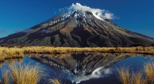
Egmont NP- Reaching 2518 metres above sea level, Mt Taranaki is New Zealand's most perfectly formed volcano. It is around 120,000 years old, and last erupted in 1775. Volcanologists agree that the mountain is 'dormant' rather than extinct.
Maori legend provides an enchanting explanation for why Mt Taranaki stands alone. As the story goes, Taranaki once lived with the other volcanoes of the central plateau - Tongariro, Ruapehu and Ngauruhoe. When he made romantic advances to Pihanga, a pretty hill that they all admired, Tongariro jealously blew his top (as volcanoes are inclined to do). Taranaki fled to the west, gouging the Whanganui River on his way.
The snow-capped cone of Mt Taranaki lures visitors who appreciate geological phenomena. Apart from one small bump - a subsidiary vent called Fantham's Peak - the mountain's cone is beautifully symmetrical. Often described as 'New Zealand's most climbed mountain', Mt Taranaki provides non-mountaineers with an achievable summit challenge.
For those interested in botany, Egmont National Park makes it possible to observe the progression of plant species from surf to summit. The lowland forest is scattered with rimu and rata trees, which gradually make way for kamahi, totara and kaikawaka. The 'Goblin Forest', on the mountain's middle slopes, takes its name from the gnarled shape of the trees and the thick swathes of trailing moss. Above the forest you'll find sub-alpine scrub and alpine herbs. A comprehensive network of walking tracks provides access to the unique beauty of the park.
(http://www.teara.govt.nz/files/hero14437.jpg)
Whanganui NP- This park encloses the wild upper and middle reaches of the Whanganui River, which is New Zealand's longest navigable waterway. Beginning beneath the shadow of the central plateau's giant volcanoes, the 329 kilometre river winds its way to the Tasman Sea through an endless procession of forested valleys and hills.
The river was once an important transport route for Maori, and many defensive pa (forts) were constructed on headlands along its sinuous course. Early European settlers and traders also used the river for transport, guiding their shallow-draft boats through the long narrow gorges that today provide so much enjoyment for kayakers. The paddling adventure that begins in Taumarunui and finishes in Pipiriki is known as the 'Whanganui Journey'.
This park encloses the wild upper and middle reaches of the Whanganui River, which is New Zealand's longest navigable waterway. Beginning beneath the shadow of the central plateau's giant volcanoes, the 329 kilometre river winds its way to the Tasman Sea through an endless procession of forested valleys and hills.
The river was once an important transport route for Maori, and many defensive pa (forts) were constructed on headlands along its sinuous course. Early European settlers and traders also used the river for transport, guiding their shallow-draft boats through the long narrow gorges that today provide so much enjoyment for kayakers. The paddling adventure that begins in Taumarunui and finishes in Pipiriki is known as the 'Whanganui Journey'.

(http://secure.connectingiseverything.com/InternationalAccommodation/AccommodationPhotos/Photos/1986-Default.jpg)
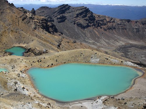
Tongariro NP- The Tongariro National Park encircles the volcanoes of Tongariro, Ngauruhoe and Ruapehu. It was gifted to the nation by Maori chief Te Heuheu Tukino IV in 1887. Just over a hundred years later, the park was awarded World Heritage Site status.
The fact that the volcanoes are active doesn't deter people from skiing down their slopes and hiking to their craters. A monitoring system provides early warning of eruptions.
The park's most celebrated activity is the 'Tongariro Alpine Crossing', a day trek that traverses the otherworldly landscape between Ngauruhoe and Tongariro. Steaming craters, old lava flows and thermal lakes make the walk an unforgettable experience.
At 2797, 2291 and 1968 metres respectively, Ruapehu, Ngauruhoe and Tongariro are sizeable volcanoes. Tongariro's huge massif extends over 18 kilometres in length - classic, cone-shaped Ngauruhoe is actually one of Tongariro's vents. Ruapehu had the honour of playing Mount Doom in the Lord of the Rings trilogy.
The mountains of this national park have deep spiritual significance for the Maori people. Legend has it that the high priest Ngatoroirangi was frozen in a snowstorm while exploring Tongariro and called to Hawaiki, the traditional Polynesian homeland of the Maori, for fire. His prayer was answered, via the channel we now call the Pacific Rim of Fire, and the mountain erupted.
The lower slopes of the mountains are blanketed with forest, which provides a habitat for many native birds. New Zealand's only native mammals, short and long tailed bats, also live in the park.
(http://www.planetware.com/i/photo/tongariro-national-park-turangi-nz740.jpg)
Te Urewera NP- New Zealand's fourth largest national park is the ancestral home of the enigmatic Tuhoe people. Legend traces the parentage of the Tuhoe to Hine Pukohurangi (the mist maiden) and Te Maunga (the mountain), which is why the Tuhoe are known as 'children of the mist'.
Beautiful Lake Waikaremoana, the focus for many activities in the park, was formed about 2200 years ago by a colossal landslide that blocked the Waikaretaheke River. The lake is more than 250 metres deep in parts, and many visitors remark that it resembles a fiord. The track around the lake is one of New Zealand's 'Great Walks'.
The Te Urewera National Park protects the largest area of native forest remaining in the North Island. The high, misty ridges are covered with silver and mountain beech. At lower levels, the forest is dominated by red beech, rimu, rata, tawa and kamahi. Nearly all of New Zealand's native birds live in the forest, including rare species such as the North Island brown kiwi, blue duck (whio), yellow-crowned parakeet (kakariki), bush parrot (kaka), New Zealand falcon (karearea) and the blue-wattled kokako.
For hikers, kayakers and fly-fishing enthusiasts, the park's main attraction is Lake Waikaremoana. From the visitor centre at Aniwaniwa, short and long walks provide access to the lake's spectacular scenery and legendary fishing spots. In a small basin above the big lake is island-dotted Lake Waikareiti, a haven for native aquatic life.

(http://www.laupichler.name/dieter/images/146UreweraLake.jpg)
Rakiura NP- Many people think of New Zealand as two islands, when it is actually three. Subantarctic Stewart Island, which lies 30 kilometres south of the South Island, has a land area of nearly 2000 square kilometres, and 85% of it is included within the boundaries of Rakiura National Park.
The most recent addition to New Zealand's national park portfolio, Rakiura is an enchanted world of unmodified ecosystems and habitats. From dense coastal rainforests and freshwater wetlands to vast sand dunes and granite mountain ranges, the park provides an exceptional opportunity to see native wildlife and primeval landscapes.
Rakiura translates to 'the Land of Glowing Skies', a name that refers to both the beautiful night-sky phenomenon called the Aurora Australis (the Southern Lights) and the breathtaking sunsets that burn on the western horizon.
Night time is very special in this park for other reasons too. While you're tucked up inside a Department of Conservation hut, nocturnal bird life provides an unforgettable chorus. You'll hear the calls of ruru (the native owl), weka and kiwi. On Stewart Island, you have an excellent chance of seeing kiwi in the wild.
During daylight, the serenade continues. Along with tui, bellbirds, tomtits, grey warblers and fantails, you'll hear red-crowned parakeets, bush parrots and Stewart Island robins. The coastal fringes of the island are home to three species of penguin, fernbirds, banded rails, weka and many kinds of seabirds.

(http://bluegumpictures.com.au/images/medium/95/95q22.jpg)
Text from http://www.newzealand.com/travel/International 4.02.2010
8.The tuatara is native to New Zealand. It is the sole survivor of the beak-heads which is a group of very ancient reptiles The tuatara is the most ancient of all living reptiles. It is even older than the dinosaurs It has survived for almost 200 million years Tuatara can live up to 100 years The male is much bigger than the female Young tuatara have a third eye. It is on top of the brain between it's other eyes. It becomes covered over when the tuatara is an adult
Tuataras are carnivores. They eat weta, moths and beetles. Sometimes they eat small lizards and even the eggs and chicks of petrels. At the zoo we feed them baby mice, huhu grubs, worms, meal worms and insects. They are fed twice a month.
Tuataras were once found all over New Zealand but now they only survive on offshore islands because of the rodents, wild cats and pigs that were introduced to the mainland.

(http://static.panoramio.com/photos/original/3863489.jpg) 4.02.2010
Kiwi are flightless birds endemic to New Zealand. At around the size of a domestic chicken, kiwi are by far the smallest living ratites and lay the largest egg in relation to their body size.]There are five recognised species, all of which are endangered. The kiwi is a national symbol of New Zealand.

(http://images1.wikia.nocookie.net/uncyclopedia/images/0/0f/CuteKiwi.jpg) 4.02.2010
Text from http://www.nz.com/
9.Sport has a major role in New Zealand's culture, with the unofficial national sport of rugby union being particularly influential. Other popular participatory sports include cricket, bowls, netball, soccer, motorsport, golf, swimming and tennis. New Zealand has strong international teams in several sports including rugby union, netball, cricket, rugby league, and softball. New Zealand also has traditionally done well in the sports of rowing, yachting and cycling. The country is internationally recognised for performing well on a medals-to-population ratio at Olympic Games and Commonwealth Games.
Rugby union, commonly referred to as rugby, is closely linked to the country's national identity. The national rugby team, the All Blacks, has the best win to loss record of any national team, and is well known for the haka (a traditional Māori challenge) performed before the start of international matches. Rugby league is also widely played in New Zealand. The New Zealand Warriors compete in the Australian NRL competition, and in 2008 the national side, the Kiwis, won the Rugby League World Cup.
Cricket was introduced to New Zealand in the 1800s and is reputedly the second most popular sport in the country, with one source stating there are 98,000 registered cricket players. The New Zealand team is known as the Blackcaps and the national women's team is the White Ferns.
Horse racing is a popular spectator sport which has spawned such national icons as Cardigan Bay and Phar Lap, and was part of the traditional "Rugby, Racing and Beer" culture.
New Zealand is also well known for its extreme sports and adventure tourism. Its reputation in extreme sports extends from the establishment of the world's first commercial bungy jumping site at Queenstown in the South Island in November 1988. The country also has a strong mountaineering tradition, with the country's most famous climber being the late Sir Edmund Hillary, jointly with Tenzing Norgay the first person to reach the summit of Mount Everest.

(http://upload.wikimedia.org/wikipedia/commons/thumb/d/db/Allblackhaka.jpg/800px-Allblackhaka.jpg) 5.02.2010
Text from http://en.wikipedia.org/
10.There are nine sheep to every human in New Zealand.
New Zealand has a lot of animals and birds. It actually has the worlds biggest flightless parrot. The worlds oldest reptile. The biggest earthworms. The smallest bats. The only native land mammals. The oldest trees.
The most famous tree in New Zealand is Tāne Mahuta, a giant Kauri tree in the Waipoua Forest of Northland Region, New Zealand, that is between 1,250 and 2,500 years old.

(http://www.visabureau.com/new-zealand-working-holiday-visa/blog/image.axd?picture=Tanemahuta2.jpg)
The biggest flightless parrot.
(http://animal.discovery.com/tv/a-list/creature-countdowns/loudmouths/images/kakapo.jpg)
New Zealand is very broad and open minded with thier laws like The drinking age is 18 but anyone under that age can drink with an adult present in restaurants.
There are 9 billion beef and dairy cattle.
New Zealand has the highest car ownership rates in the world.
Text from http://hubpages.com/hub/Fun-Facts-About-New-Zealand 6.02.2010

No comments:
Post a Comment